The City
10.20.2003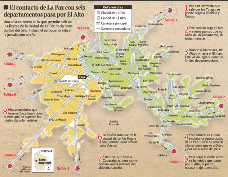 Here's a map of the twin cities of La Paz & El Alto from Sunday's La Rázon. If you wondered about the neighborhood names I reference, this gives a decent idea of what I mean. Click on the map to enlarge it.
I live in La Paz (green). Specifically, I live near the Prado (almost the exact center of the map), which is on the main road through the center of the city, just right of San Pedro (near the "o"). Follow the road south, you hit Sopocachi. The capitol and Plaza Murillo is just up from me, just south of the Casco Viejo (the old colonial district).
The Zona Sur's the area past Obrajes. My tía Theresa lives in San Miguel, a sub-neighborhood of Calacoto, close to Los Pinos (where my friend Daniel lives). My tío Juan lives just north of them, in Alto Irpavi. Tía Juana lives south, towards Salida 3, in Aranjuez.
If you're wondering what the map explains: It shows La Paz's vulnerability. W/ 8 highways out of the metro area, the 3 out of La Paz itself, actually go nowhere (at least to no major urban areas). Of the 5 out of El Alto (which can all be closed at the Ceja), only Salida 4 leads to any major cities. Also, keep in mind that La Paz is built in a series of mountain ravines. So the three roads out of the city are the only way out, unless you want to climb some Andean mountains.
-----
UPDATE: I've since moved, and now live in Sopocachi.
Posted by Miguel at 11:25 AM
Comments